

A short and relatively gentle trek combining Sinchula and Dagala Thousand Lakes Trails coverng Districts of Punakha and Thimphu, this trek provides an overall impression of the land, the people and the history of the last independent Buddhist Kingdom. One of the most remarkable aspects of the country is in its overall degree of separation from the outer world. You will witness many of Bhutan's defining characteristics and fascinating contrasts, both immensely refreshing and stimulating to find oneself in a situation so different from the familiar.
Bhutan is renowned for the enduring strength and vitality of its traditional Himalayan Buddhist culture and the dominance and purity of its natural environment. This journey through the country's west encapsulates both these elements; touring the major historical centers and stepping off the beaten track, into a world that not long ago existed throughout the country and for many still represents the norm. There is a particular emphasis on traditional arts and crafts, observing the perpetuation of skills that have been carefully maintained through the generations.


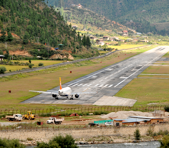
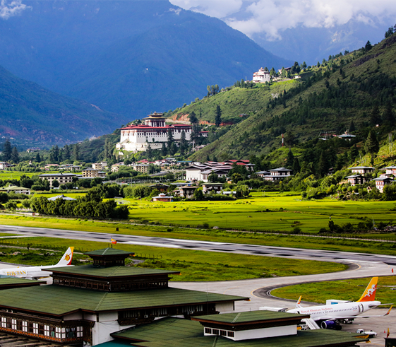
We transfer to the airport for the flight to Bhutan’s only International airport at Paro. The flight from Bangkok to Bhutan is one of the most spectacular of all mountain flights. From the left side of the plane Everest, Makalu and Kangchenjunga, three of the world’s highest mountains, are clearly visible. The total flying time is only 45 minutes and soon we are descending into the Paro Valley, enjoying the splendid views of alpine forests, small monasteries, temples and flat-roofed farmhouses. A single road lined with willows, clear mountain streams, families working in the roadside fields and one of Bhutan’s most impressive Dzongs (fortress monasteries) creates a memorable first impression.
One of the most visible sights in the valley is the Ta Dzong, a circular fortress that once protected this valley from Tibetan invasion. The impressive watchtower commands sweeping views of the valley below. It also houses Bhutan’s National Museum, which, since 1968, has been the home of the country’s most cherished relics. (Unfortunately the Ta Dzong was damaged in a recent earthquake, and has been closed for repairs until further notice. The Museum’s treasures have been temporarily moved to another building).
From the Ta Dzong, we start on a moderate two-hour hike that takes us to the Zuri Dzong. This structure dates back to the 14th century and contains temples to the local protective deities. Presently it also houses hermits and scholars who specialize in indigenous medicine. We enjoy great views of the main dzong and the entire valley as we descend through the cypress and pine trees on a sometimes steep trail to the Paro Rimpung Dzong. We will walk from the Dzong towards a traditional cantilevered bridge below, spanning over Pachuriver and across the highway, you will see Buddhist Art Gallery where you may want to check onto local master artisans working on Bhutanese thangkas
Distance: 1.5/0.9Miles
Time: 1 Hour leisurely
Elevation gain: 40m/135ft
Elevation loss: 60m/190ft
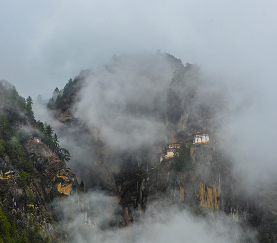
A stunning excursion to one of the most important religious site in the entire Himalaya is planned for today; he hike to Taktsang Temple or Tigers Nest is a must do while we are in Bhutan and recommended be done early for the 800-meter climb.
In the morning, drive up to the base of Taktsang to start your hike to this iconic monument, perched on a vertical granite cliff 2000 feet above the valley floor. The legend of Taktsang dates from 747 CE, when Guru Rinpoche, in the wrathful form of Guru Dorji Droloe, arrived here on the back of a tiger and subdued the evil spirits of the region. You drive to the trail head and, like many pilgrims before, hike up a mountain path toward Taktsang. After about one hour of rather steep hiking, you can rest for a while at a small teahouse with wonderful views of the monastery. If you choose to walk another hour, you can get an even closer look from the small chorten directly opposite. The final stretch climbs down—and then back up—700 steps, crossing a gorge over-laced with prayer flags to arrive at the incredible destination. Enjoy the walk and the experience.
Distance: 8.5Km/5.3Miles
Time: 5-6 Hours Return
Elevation gain: 600m/2,000ft
Elevation Lloss: 600m/2,000ft
In the morning drive across 10,223-foot Dochu La, which in good weather offers 360-degree vistas across 200 miles of Himalayan peaks including Bhutan’s tallest peak and some of the highest unclimbed mountains in the world! There are 108 stupas adorning the pass. Spend some time walking around and admiring the landscape here before continuing drive to Punakha.
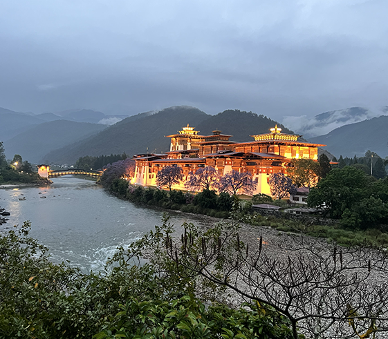
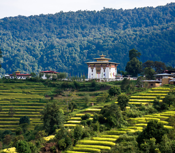
Punakha was the ancient capital of Bhutan until mid-1960s until it was shifted to Thimphu. The valley hosts one of the impressive fortresses in the world. The temperate weather conditions favors for the cultivation of rice, chilies, vegetables and tropical fruits. Punakha Dzong, set at the confluence of the Mo and Po (or “mother” and “father”) Rivers. Built by Shabdrung in 1637, this massive fortress is one of the holiest in Bhutan and holds some of the country’s most sacred relics. The central monk body moves from Thimphu to Punakha every winter to take advantage of Punakha’s temperate climate. Take your time to explore and admire the architecture and photography time aplenty.
After breakfast we drive up to Hebisa village and from here, the route is on dirt roads to Chorten Nyebu (1,700m/), an ancient temple dedicated to Divine Madman. The trek today is gradual ascent through terraced fields and several villages along the way.During monsoon, you will notice farmers planting paddies and during late fall seasons, they will be harvesting. After crossing two streams and climbing steadily through forests of blue pine and rhododendrons, we reach a clearing, which is our camp for the night at the place known as Dupshipang.
Distance: 9Km/5.6Miles
Time: 6-7 Hours
Elevation gain: 740m/2,440ft
Elevation loss: NA
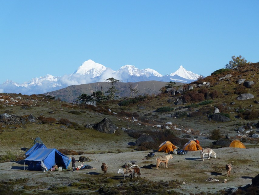
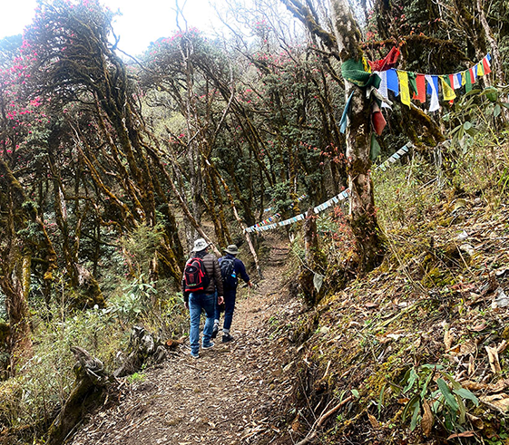
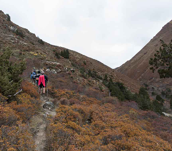
Today morning we begin trekking up towards SinchuLa (3530m/11,640ft) through mixed forest with the views of Thinleygang village, Talo Monastery and the main road to Punakha in the distant. After approximately 4-5hours we reach Sinchu La pass (3530m), marked with a small white-washed Stupa. This route was used in the ancient times by our forefathers to shift their residences during winter and summer times between Thimphu and Punakha. From the top of the Sinchu La we descend to a meadow (3485m), surrounded by rhododendron and mixed conifer forest and ascend up for another 2 hours to reach to our serene campsite in a meadow in Thandana.
Distance: 16Kms/10Miles
Time: 8-9 Hours
Elevation gain: 1,010m/4,600ft
Elevation loss: 100m/330ft
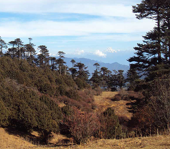
Today's trek is relatively gentle with some occasional uphill climbing through dense forests of oak and blue pine forests. The trail is still used by the yak herders but remains intact and fresh. We may chance to come across a yake herder’s camp along the way during winter. On your left as you near to Dochula, you will get an amazing panorama of Bhutan's tallest seven peaks of Bhutan. Over Dochula pass, there are 108 mini stupas adorning the landscape and the Himalayas in the backdrop.
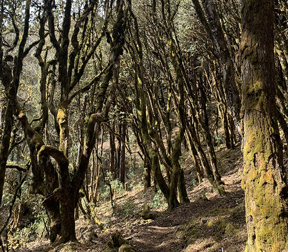
From Dochula, we climb up higher up the ridge, then down and up again through a forest of hemlock, birch and rhododendrons. The trail follows the north side of the ridge until we reach a small meadows for yak herders (below Lungchutse Lhakhang) where we will camp for the night. During spring seasons, the whole forests is covered with varieties of rhododendrons and magnolias.
Distance: 17Kms/10.6Miles
Time: 6-7 Hours
Elevation gain:360m/1,188ft
Elevation loss: 570m/1,550ft
In the morning after leisure we trek up through juniper and rhododendron until we reach up to Lungchutse Lhakhang (3,600m/11,880ft) and enjoy the morning sunlight and the Himalayas including Bhutan’s holy mountains towards the extreme left. After leisure time around and a visit to this remote temple, we will descend through the forest of pine and dwarf rhododendron. We will then cross over Hele La pass (3225m/10,640ft) on a diversion that has also a way leading towards Wangdue near Punakha valley.From the pass we will gradually descend down towards our camp just before reaching the small village of Chamgang. The trail along the way is a logging area as you will notice from the logging roads crisscrossing over. Your campsite for today will be in a clearing set in the bushes.
Distance: 15Kms/9.3Miles
Time: 6-7 Hours
Elevation gain: 450m/1,485ft
Elevation loss: 420m/1,386ft
Today’s trek takes us through the quiet settlement of Chamgang with few hundred houses. From here our path first leads up through orchards of apples, before a long gradual climb through forests of spruce, birch, juniper, oak and rhododendron. The forests along this route is filled with wild life activities including birding and also an opportunity to see Bhutan’s national flower, blue poppies.
Today’s climb can be strenuous and so we will take our slow pace until we make it up to to the top and then camp out in a clearing that once used to be a lake. This is a winter meadow used to graze the Yaks when the herders bring them down from the higher mountain slopes. Enjoy the evening clear blue skies over head and rejuvenate yourselves for the following days.
Distance: 6Kms/3.7Miles
Time: 5 Hours
Elevation gain: 600m/2,000ft
Elevation Loss: NA
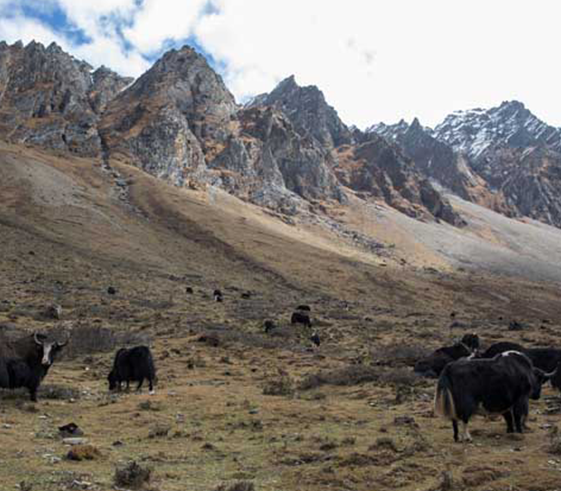
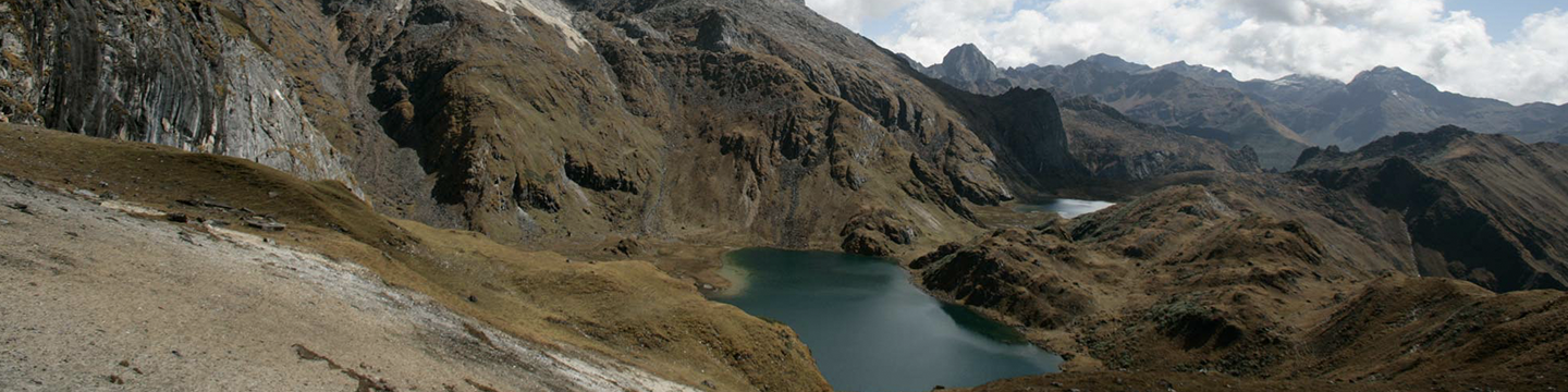
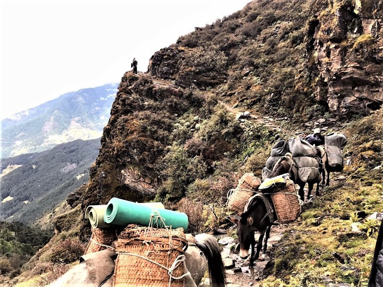
Today yet again, we will begin our trek with a steep ascent for about an hour beside the Dokka Chu. We are likely to see the tents of semi-nomadic Yak herders along the way and sight Himalayan Monal Pheasants as they are common in this region. The views of the Himalayas today are magnificent as we climb over several ranges to reach the Tsari La (4190m/13,825ft). We descend down from the pass and then climb up for around another hour to our camp site at LhabaChung, located below a lake. The campsite has been used for centuries by the yak herders as their summer grazing grounds.
Distance: 10Kms/6.2Miles
Time: 7-8 Hours
Elevation gain: 1,100m/3,630ft
Elevation loss: 470m/1,550ft
On today's hike we will have impressive views of the Himalaya. We start by ascending up to Laba Chung Lapsta at 4520m/ 14,916ft, the highest point on this trek- an hour ascent. From here you sight Kanchenjunga in India as well as the Bhutanese peaks of Masang Gang, Gangchhenta, Tsenda Gang and Jichu Drake. From the pass we descend and follow the emerging stream downhill for a while to the main hill top over Labatama pass where you can see your campsite far below.
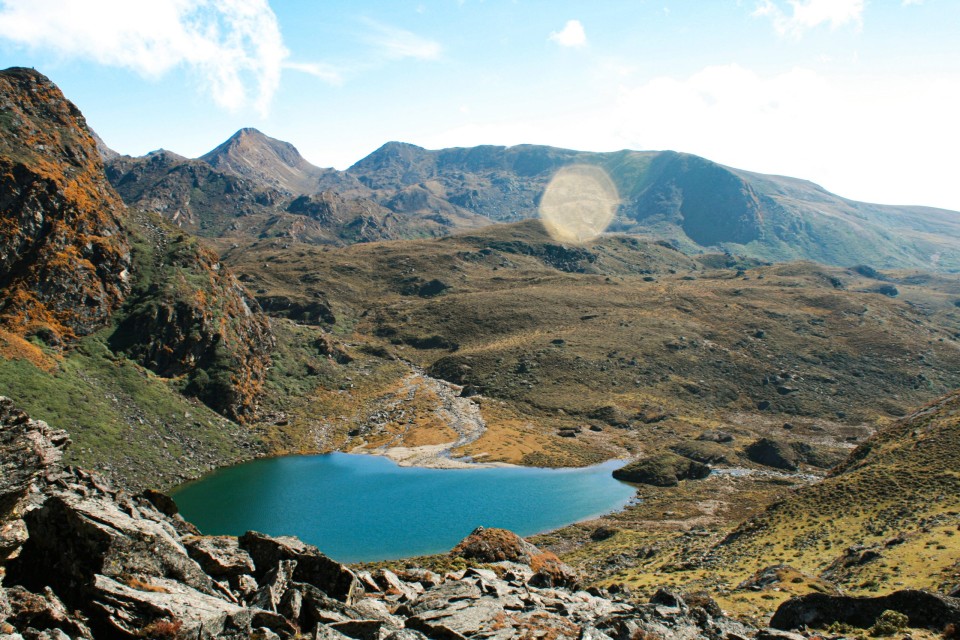
But we will take a detour and explore around, visiting the sacred Relitsho, Hentsho or Jametsho Lake (tshomeans lake). Your guide will share you the mystic stories of these lakes. There are fresh brown trout’s in these lakes, although fishing needs a special permit. Treat yourself with picnic lunch on a spot your guide will arrange and leisure walk down towards Labatama Valley where there are scattered yak herders' huts. We will visit one of the yak herder’s tent and meet the families living here and learn from their stories living in this part of the Himalayas.
Distance: 8Kms/5Miles
Time: 6-7 Hours
Elevation gain: 320m/1,056ft
Elevation loss: 420m/1890ft
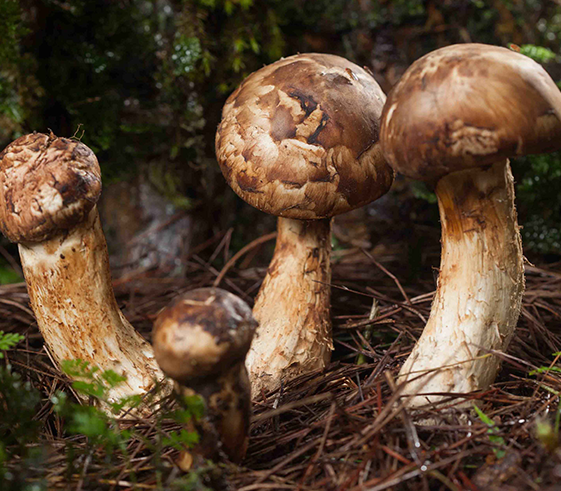
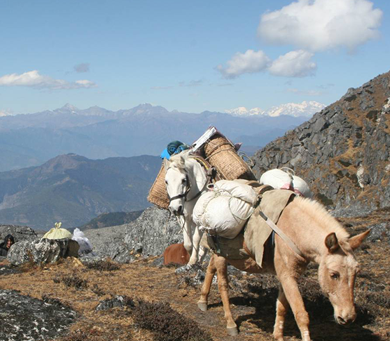
Today we will cross over Pangalabtsa pass (4250m/14,000ft) dotted with many prayer flags. From here you can enjoy the views of the entire Dagala range and most of the Bhutanese Eastern Himalayan peaks. And then we begin our long gradual descent following a broad trail down the ridge to the Yak pastures of Gur (3290m/10,855ft) and further to asuspension bridge spanning over Gaynitsangchuriver. Then the trail leads through farm road to the village of Genekha (2,930m/9,684ft). The region here is famous for harvesting of matsutake and chanterelle mushrooms that grow wild in the forests. This is here your car will pick you up and drive us to your hotel in Thimphu.
After checking in and taking a welcome hot shower we will go out to explore Bhutan's capital city.Thimphu is home to the government, royal family, and the head offices of international aid organizations. Local shops entice with traditional weavings; Tibetan and Bhutanese silverwork; coral and turquoise beads and prayer flags. A number of cottage industries, including metalworking and paper making are found in Thimphu, and visitors often enjoy visiting their workshops to see artisans practicing their craft. Free time / Souvenir in town and option to dine out on your last night in Bhutan!
Distance: 9Kms/5.6Miles
Time: 6-7 Hours
Elevation gain: 150m/495ft
Elevation loss: 960m/3,168ft
This morning you will drive to Paro- 1 ½ hours. Your guide and driver will bid their farewells from here. We hope you had a wonderful time in Bhutan with us. We look forward to keeping in touch and seeing you again in near future. Bon Voyage, TashiDelek!

